
By Jerry Choong
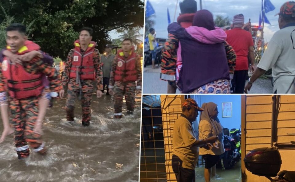
SHAH ALAM, Nov 10 — All Selangor agencies have been marshalled to move to several localities, amid reports of floods and rising water levels due to the heavy rains and high-tide phenomenon.
Menteri Besar Dato’ Seri Amirudin Shari said the relevant agencies and their machinery have been told to be on standby, as several areas in Kapar and Meru have reported rising water levels.
“The state government is closely monitoring the situation as it develops. The assets and machines from the Fire and Rescue Department are being mobilised.
“The local authorities and District Disaster Committee are readying. Here is a list of the important numbers in Klang district, for emergency use,” he said on Twitter.

In a statement, the Drainage and Irrigation Department said that based on the forecast made by the Malaysian Meteorological Department (MetMalaysia) and the Southeastern Asia-Oceania Flash Flood Guidance System, the risk of flash floods in several locations is likely due to the significant heavy rains and thunderstorms.
“In Selangor, these include the district of Klang and the localities of Kampung Teluk Gong, Taman Daya Meru, Pekan Meru, and the surrounding areas,” it said.
Other states and territories which are similarly at risk include Rompin, Temerloh, and Kuantan in Pahang, Mersing, Muar, Segamat, and Tangkak in Johor, Kuching in Sarawak, Alor Gajah in Melaka, and Port Dickson in Negeri Sembilan.
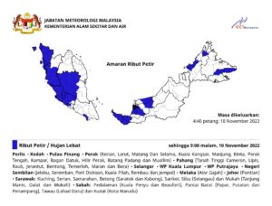
Meanwhile, MetMalaysia said heavy rains, strong winds, and thunderstorms are inbound for a good part of the country, including all of Selangor until later tonight.
In a statement issued at 4.40pm, the agency said the other states and territories include Perlis, Kedah, Penang, Kuala Lumpur, Putrajaya, Alor Gajah in Melaka, and Pontian in Johor.
“Similarly, Perak (Kerian, Larut, Matang Dan Selama, Kuala Kangsar, Manjung, Kinta, Perak Tengah, Kampar, Bagan Datuk, Hilir Perak, Batang Padang and Muallim), Pahang (Tanah Tinggi Cameron, Lipis, Raub, Jerantut, Bentong, Temerloh, Maran and Bera), and Negeri Sembilan (Jelebu, Seremban, Port Dickson, Kuala Pilah, Rembau and Jempol) will also see strong weather.
“In East Malaysia, Sarawak’s affected districts include Kuching, Serian, Samarahan, Betong (Saratok and Kabong), Sarikei, Sibu (Selangau) and Mukah (Tanjung Manis, Dalat and Mukah), while in Sabah they are Pedalaman (Kuala Penyu and Beaufort), Pantai Barat (Papar, Putatan and Penampang), Tawau (Lahad Datu) dan Kudat (Kota Marudu),” it said.
The weather is expected to persist until 9pm.
MetMalaysia issues warnings whenever signs indicate a thunderstorm with a rain intensity exceeding 20 mm that is close to or is expected to occur for more than an hour.
A thunderstorm warning is a short-term warning valid for a period not exceeding six hours for a single release.